Our trip this summer will be a short one, just a loop through the western US. Our first stop was at the Yreka RV Park in Yreka, California. Site C2 suited us fine for one night, even though it was a bit out of level. Nessies leveling system took it in stride and we settled in after a 300 mile drive north on I-5, the major highway north and south from the Canadian border to Mexico, and right through the heart of California. The highway is in good shape, and easy to navigate (just hook a bungee cord to the steering wheel and go take a nap). Not a lot to see, but as we crossed Lake Shasta, we couldn't help taking a photo of boaters on one of the huge arms of the lake on a fine, warm, summer day.
Site C2:
In order to get to US 97, we had to backtrack a bit on Sunday, but the sight of Mount Shasta made it all worth while!
Taking the 99/97 cutoff out of Granada, we found ourselves getting a close look at Mount Shasta.
A quick 174 miles later, we arrived at Big Pines RV Park in Crescent, Oregon, and were escorted to site 29, one of the easiest to get into rv sites we've ever been assigned; we drove a hundred yards down a road from the office and straight into the site!
We celebrated Fathers Day via phone, text, and FaceTime, and I enjoyed some extraordinary chocolate chip shortbread cookies from my daughter? It was a nice afternoon!
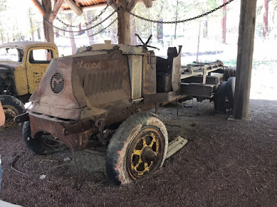
On Monday, we packed a lunch and headed south toward Crater Lake, Oregon. On the way, we stopped at the Collier Memorial State Park Logging Museum. The self guided tour takes a visitor from days of horse drawn high wheel carts and Misery Whip two man saws all the way to the production days of the mid-twentieth century.
As time and technology progressed, steam power was used wherever possible. This contraption was used to load logs onto rail cars, and was made by the Clyde Iron Works in Duluth, MN.
A number of old trucks, tractors and wagons were on display, from this solid wood wheel (yes, those are cut from trees!),
To this GMC 950, proudly labeled a "Diesel"
And this old Mack.
Continuing our day trip, we headed toward Crater Lake. Our first view was of the former Mount Mazama from 30-odd miles away. The collapsed cone is clearly visible as a bowl shape with a distant snow covered peak beyond. At this point we were at about the same elevation as the bottom of Crater Lake.
The water in the lake comes from snow. There is no other inflow, and there is no outflow. After the collapse of the cone, magma continued to rise, effectively sealing the bottom of the crater. Wizard Island, on the left in this photo, is a small cone that rose after the collapse from the floor of the crater.
The color of the water remains a deep blue. No boating or fishing is allowed.
Had to get at least one shot of Mama and the Lake!
As we began to wander away from Crater Lake, we noticed mountain ranges in the west that put us in mind of the Blue Ridge Mountains!
A momento:
So we sadly left this amazing natural wonder! It has been near fifty years since we last wondered at this lake, and it continues to amaze us!
So, after a one hundred and seventy six mile loop, we returned home to a warm evening and a cool drink! Hot sausages from the grill and corn on the cob put us into bed for a great nights sleep!


No comments:
Post a Comment