Monday, October 7, 2013

Plan B Rocks!

Since our plans to visit Mesa Verde fell through (thank you, &^*#$%^ politicians), (I just love doing that), we proceeded to plan B, which was to take the San Juan Skyway.

The San Juan Skyway is a 262 mile highway loop north from Cortez, CO, through several small towns: Dolores, Rico, Stoner, and along some of the most spectacular scenery in the world.


The fall foliage is in full display in these parts, and we couldn't drive a mile without seeing another picture that had to be taken.


We had to stop and take a look at Lizard Head Peak:


Which is at Lizard Head Pass, elev 10,222 feet!  They do grow 'em tall out here!

We made a quick side trip into Telluride, just to see out the upper crust lives.  This is the valley where the town is located; the ski runs are on the mountains around the town.


Beautiful valley, but we didn't even get out of the truck there.  Just drove through and waved goodbye.


Our next stop on the Skyway was a little mining town named Placerville:


A neat little town stuck in the 1890's, albeit with an operational Post Office.  The outside of the building is like most of the buildings in town, weathered and worn.

Our next stop was along the road near Ridgway, CO, where the view of the mountains was perfect.  A nice couple from Grand Junction took our pic, and told us that the land was owned by the Double RL Ranch, which is owned by Ralph Lauren, of clothing fame.


After making the "turn" at Ridgway, we drove to the old mining town of Ouray.  Ouray is tucked into an Alpine valley, and is, without a doubt, the most beautiful area we saw today.


The climb out of Ouray was very steep and crooked, and Donna covered her head and talked to the dog for about a half hour! We made our way to Silverton, Colorado, which is another town just like Telluride, where the mining and history are still there, but everything has a glitzy, shiny, touristy facade.  Not our cup of tea.

South on 550 to Durango and then west to Cortez completed our days journey.  A long day, yes, but one filled with hundreds of memories of mountains, trees, historical sites, and quality time together.  We went over 3 tall mountain passes, the highest of which was Red Mountain Pass at 11,075 feet.  We checked out the remnants of any number of old mines and learned that hundreds of millions of dollars in Silver were taken from these hills.  The southern Rockies are spectacular!

Sunday, October 6, 2013

Moving West

We left the Alamosa, Colorado, KOA this morning at about 10.  It was still chilly; the low at 5 am was 16 above, but by 9 or so, it had warmed up enough to move without shattering something.


You can see there weren't very many customers today; I guess the season is coming to a close.

We stopped for fuel at the Monte Vista Co-op station and headed west after coming within literally 1/2" of a huge concrete barrier set near the gas pumps. It was about 2' wide by 2' high and 6' long, and painted red. How I didn't see that I'll never know, but "Mercy, mercy" we missed it. Could have been a very expensive tank of fuel. Big, deep, breath and off we went.  Our first taste of Colorado Fall came into view as we started up Wolf Pass.  The Aspens are turning, and the scenery was gorgeous.


The pass topped out at 10,857 feet, and Nessie worked hard for every foot of that.  Of course, she's pulling a lot of weight with a full size truck behind, and the truck is loaded with way more weight than it should have, also, but the drive through the pass was very pretty.


At one point we passed through an avalanche tunnel, which was kinda scary.


But wonderful and necessary in the winter, I'm sure.  Just as we began to drop down into the valley, we couldn't help ourselves, and stopped in the middle of a switchback to take a pic:


We met some nice people there who somehow got into the picture:


Just about broke the camera!

From Wolf pass, Hwy 160 took us through Pagosa Springs, which is a super upscale place from the look of some of the homes, and then through Durango, which has a huge western history, and then on to Cortez, Colorado. We're staying in the Sundance RV Park in downtown Cortez. It's nothing to write home about.  Clean, but small, and we're within awnings' width of our neighbors.  Oh, well.  We planned to visit Mesa Verde National Park while we were here, but "due to the government shutdown.....". We do have an alternate plan, though, which we'll share with you tomorrow.  

PS: Nessie's odo turned past 8k miles today, meaning we've put on over 5k miles since Oregon 2 1/2 months ago.....

And another PS:  Happy Birthday, Dad.

Saturday, October 5, 2013

A Needle in a Haystack, or...

A sod house in a potato patch.  My Mom's family lived in the San Luis Valley of Colorado in the '20's and before, and near as we can tell, still have a presence here.  We left Alamosa, CO, this morning determined to find some trace of them.

Our first stop was one of curiosity, because we didn't know the Rio Grande River was here.  It winds through the center of Alamosa, so we stopped to take a picture.


The next stop was at the Saturday Farmer's Market, where among other yummy things, we bought some peppers for stuffing.  They are an unknown brand, but are similar to Anaheim peppers, only with a kick.  Four peppers for a buck was a killer price.  BTW, they were delicious!  Another vendor was selling roasted peppers which a young man was roasting in a rotating wire drum over a fire.  Turning the drum by hand probably wasn't his idea of a great Saturday morning, but made for some delicious peppers!


Then it was off to Monte Vista.  We had learned that my maternal great-grandfather had participated in the Cherokee Land Rush in Oklahoma back in the day, and staked out his land per the regulations of the day.  Unfortunately, he was not inclined to be a farmer, so left Oklahoma and set up a trading post near Trinidad, Colorado, where he could supply both people bound for the west and the cattle drives from the south.  One of his sons, George, married my grandmother and they moved to Monte Vista, Colorado, where my mother was born.  The location of her birthplace is the needle we've been seeking. My mother and her family left the area for California when she was just a wee thing, loading all their belongings into a Model A and heading west.  Just like the pioneers, they struggled to get over the Rockies and had to abandon a lot of their belongings while pushing the car from behind.  Sturdy people!  We had a couple of names in the area, and we had the memories of my Mom when she and my Dad visited the area many years ago.  Unfortunately, we were not able to locate the house my Mom was born in.  We did locate a number of people with her maiden name, so evidently some of her fathers family remained in the area.  We will continue to search old records and perhaps return to the area one day.

We did take a couple of pictures of some interesting old buildings out in the farmland (which by the way, is great for raising potatoes, carrots, and Alfalfa hay). The carrots are marketed under the name of Grimway, which Donna says is the brand she buys at home.  What if.....


Tomorrow we're movin' on.  We've enjoyed our brief stay at the Alamosa KOA.  I didn't think I'd ever say that I enjoyed a KOA, but this campground is far different than most.  The sites are spacious and level, the utilities are more than adequate (wifi is superior), and the owners are wonderful people.  Bob has lived in the general area his entire life and is a huge source of information about things to do and see.  Both he and his wife are super friendly, super supportive, and are willing to go the extra mile for anything their customers want.  They are continually expanding and improving the park, so it will definitely be a place for us to return to when we're back in the area.  Thumbs up, for sure!


And the pizza was great!

Friday, October 4, 2013

The San Luis Valley

We left La Junta this morning about 9 with a slight breeze and cool temps.  The terrain across the southeastern part of Colorado continued to be flat.


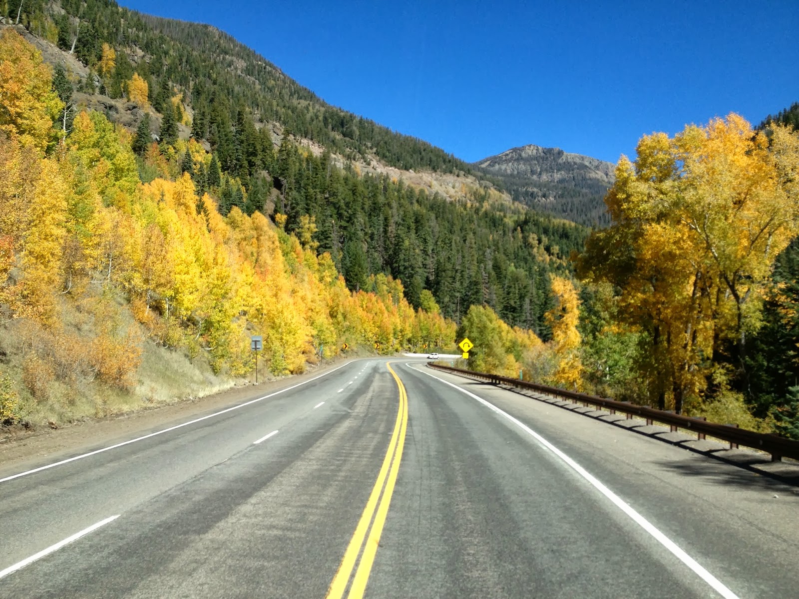
But as we continued west and began to climb the Rockies, the terrain and the tree colors changed dramatically. The Aspen trees are starting to turn and are beautiful!


We topped La Veta Pass as 9412 feet and started a long gentle descent into the San Luis Valley to the town of Alamosa, Colorado.  We're staying at the Alamosa KOA, one of two rv parks in the area.  The other one is the Alamosa Economy RV park, and it is for sale.  Let your imagination go with that.  We're in the area because the town of Monte Vista, Colorado is 18 miles west of Alamosa, and my mother was born in Monte Vista and I wanted to see her home.  We know little of the area in the 1920's, and most of what existed then is gone, but it is worth a shot.  We got into Alamosa early this afternoon, so we took a drive into Monte Vista to scope things out.  Our first stop was at the Monte Vista Co-op, figuring that if my Moms family were farmers, there might be some old records available.

The records idea didn't pan out, because of a fire that occurred some years ago that destroyed some of the years that we needed. However, I met four great farmers from the area that gave us all the information they could.  One of the gentlemen gave me the name and number of a now-retired real estate person that has been in the area all his life, and is one of those "if anyone knows where the house is, he will" fellows.  I'll try to contact Sid tomorrow. I enjoyed talking to these guys and I think that they enjoyed talking to me, because they kept telling me that I needed to get some "long pants", and I kept telling them that in California we don't put on long pants until Halloween.  They retorted that I wasn't in California.....You just can't get the best of these farmers! They told me that they gather at the co-op every morning at 6:30 and every afternoon at 3 at the "Table of Knowledge".  Except for Bob, who was not considered to very smart this afternoon, because he started a pot of coffee and then left for the restroom.  Unfortunately, he forgot to put the empty pot under the grounds.....

The boys told me to go to "287, turn north to County Road 7 (7 miles from town), and that's potato country".  Well, my Mom's family raised potatoes in the 1920's, so that's where we went.  Downtown Monte Vista is undergoing some much needed restoration,


but we found hwy 287, and headed out of town.  A cold front was moving in, so the skies were ominous to the north and west,


and we didn't waste much time.  We drove both west on CR 7 for a few miles and then east on the same road, looking for something that might look like the farm that Mom described to me.  We found several houses that certainly looked like they could have been around in the '20's, but didn't have the nerve to do more than snap a few pix.


As we left CR 7, we passed a school where they were preparing for Friday Night Lights!  We couldn't quite figure out why the agricultural spray equipment was stationed at each end of the field, but there was no denying the light poles and the yard markings on the grass!


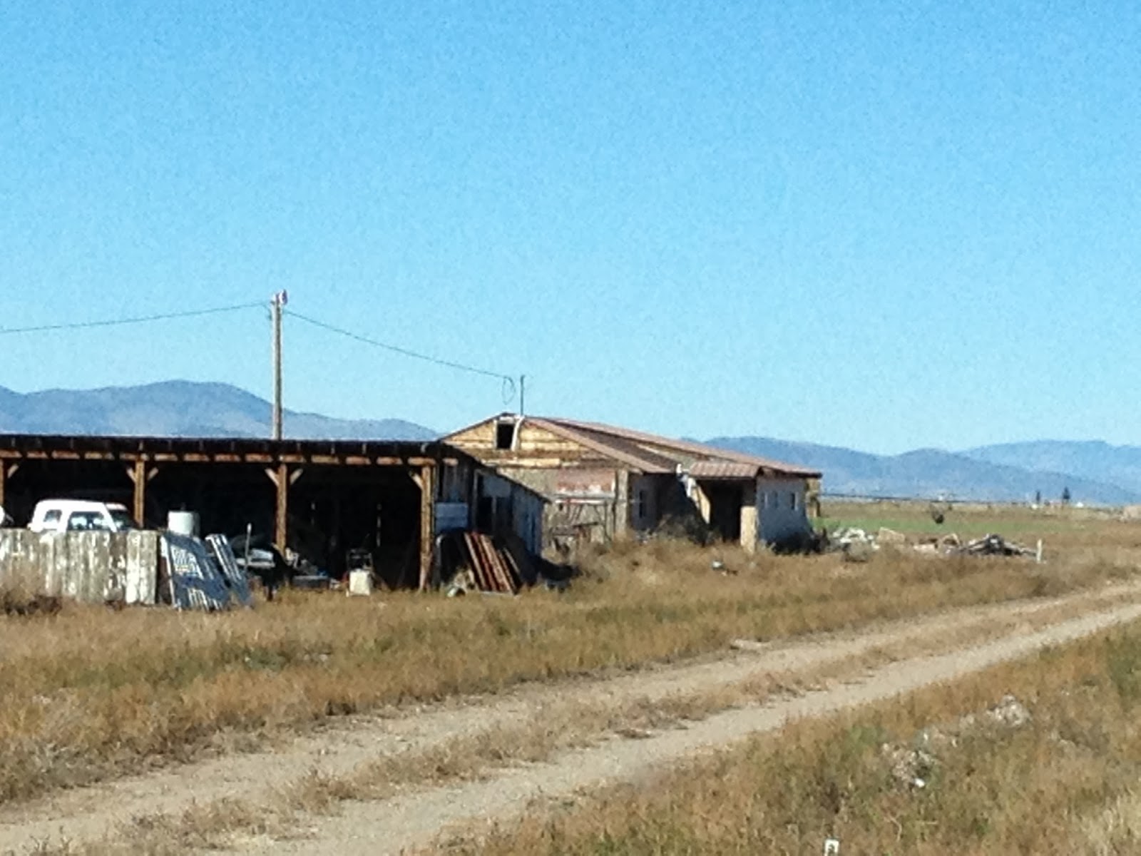
Just past the school, we saw the remnants of what was once someone's farmhouse. The fields around this place have been converted to "circles", where huge irrigation pipelines rotate in circles and the crops, whether hay or potatoes, is harvested from these circles.  This method leaves odd spaces between the circles that have been left natural, and that's where we saw this:


Just some crumbling buildings to remind us of the harsh conditions that people lived and worked in a hundred years ago.  It's impossible for us to imagine what it must have been like to live in a sod house, or haul lumber for the new house from the hills miles away.  People were a lot tougher then.

BTW, the owners of the RV park provided us with a hot pizza delivered to our door this evening, Thank You Bob and Denise!, and we got to talking about the weather.  It's predicted to get down to 19 above tonight, so two things will happen: the water hose will come in tonight so it doesn't freeze, and tomorrow will be the first time for long pants since last July.  Sadness runs rampant amongst us.  Bob tells us that the park will close next week for the season.  He has about 2 weeks to prepare for winter, which consists of very little snow, but -40F and 40 mph winds...Wow!  We gotta get out of here!

Thursday, October 3, 2013

70, 40, 287, and 50!

We left Hays, KS, this morning early, because that's what you do when you stay in a Walmart parking lot overnight and the trucks start rumbling at 6 am outside your window.  We had an enjoyable evening in Hays, even though it was very hot and humid.  A strong breeze came up about 9 pm and blew all night, and cooled things off very nicely.  We were able to sleep with the windows open all night because we were able to park along side the edge of the parking lot so that the larger slide was out over a grass strip and the bedroom slide was away from the traffic pattern.

A hundred or so miles west on I70 brought us to the US40 turnoff.  Right about there the weather deteriorated drastically.


The terrain became "Kansas Flat", and the clouds started gathering.  For a distance of about 20 miles a mixture of clouds, ground fog, and rain made visibility difficult.  Thank goodness the road was straight and the traffic light!

We stopped for lunch a few miles before we entered Colorado, at Pond Station, an original Butterfield Stage stop.


Yes, those are the bullet holes!  The sides of the building are scattered with bullet holes.  I can only imagine the people inside listening to the sound of the bullets hitting the walls.  The wood is rough cut, so it is over 1" thick, but still it must have been un-nerving to say the least.

Out in front of the museum, a metal sculpture of a buffalo seems to be enjoying the taste of Nessie:


A few mlles farther on, and we turned south on US287.  This part of Colorado is flat, flat, flat:


It is, if possible, more Kansas Flat than Kansas.  The saving grace was that the road was excellent, and the clouds cleared, so it was an easy drive to our old friend US50, where we turned west.  US50 is notable in that it passes within a 1/2 mile of our front door at home, so it was kinda nostalgic to see it again.  US50 took us west to the town of La Junta, CO, where we set up shop at Walmart again.  With permission granted at the Customer Service Desk, we found another nice spot along the side of the parking lot, so that Pris could have a bit of grass to play on.  A little shopping, dinner at the Village Inn because it was a short walk away, and we were back at Nessie ready for the evening. A nice day was had by all!

Wednesday, October 2, 2013

Yes, ToTo, this is Kansas.

Off this morning from Independence, Missouri, on I70 west into Kansas.  The eastern part of Kansas is very rolling terrain, with some pretty steep hills in places.  We were surprised the other day when we pulled into Independence at how "hilly" the town is.  Lots of trees and grass and a whole lot of hills!  Just a few miles into Kansas, the terrain flattened out:


And eventually became very flat:


I70 is, for the most part a long, straight, uneventful highway.  The first 30 odd miles from Kansas City to Lawrence, KS, is a toll road where we lost control of $6.75.  The toll road was in remarkable condition, however, and so the cost was certainly justified.

We stopped for lunch at a rest stop and took a few pix:


We passed Ft Riley, which is still a very active Army base, and noted that it is the home of the museum of the Seventh U.S. Cavalry and the Custer home.  We'll have to come back for sure!

So, 274 miles farther west, we're escounced in the northwest corner of the Walmart parking lot in Hays, Kansas.  This is a new experience for us, but should turn out ok, as the person at the customer service desk told us that we would have lots of company before the night was over!

If you'll forgive a small rant, we were going to stop for two nights in Abilene, KS, to visit the Eisenhower Presidential Library and Museum, and to support the local economy a bit.  Guess what happened to that plan.... So the local merchants lost, we lost, and the @$^! politicians in Washington lost....even more of my respect.  I think I'm down to about 2% now...

Tuesday, October 1, 2013

&*^% Politicians!

Our plan this morning was to visit the Truman Presidential Library and Museum. So much for that plan.


So we went to Independence Square, in downtown Independence.  The square is dominated by the Courthouse,


and surrounded by historical sites.  There is the Marshall's office and jail from the early 1800's all the way up to the drugstore that Mr. Truman worked at before he became a county judge.


We stopped for a cup of coffee at Main Street Coffee on the east side of the square.  Donna ordered a "Dirty Chai Latte", which is a Chai Latte with a shot of espresso and pronounced it delicious.  I ordered an Aztec Emperor, which is a Cinnamon Mocha.  So-So.  Service was distinctly unfriendly.  We walked down the block to the confectionery and ogled the home-made fudge.  The proprietress was so nice and gave us much information on the history of the buildings in the area and shared some of her personal stories as well.


Her "ride" was parked outside.  She purchased the Breast Cancer scooter just months before her daughter died of the disease.  A sad story.


After trotting around the square, we drove into the older part of town to gander at the old houses, and happened upon this gem:


Which turned out to be a famous residence:


Then we returned to the Frontier Trails Museum that we had started to tour yesterday afternoon.  This particular museum focused on the various pioneer trails that started in Independence, and went west to Oregon, California, and Santa Fe.  This is a new approach to the westward movement, and it was fascinating to learn about the huge sacrifices made by those pioneers. We were particularly interested to see paintings of Independence at that time:


The first painting shows the wagon trains as they approached the Missouri River crossing near modern day Kansas City, after having left Independence Square.  The other painting shows the Square with all the hustle and bustle of thousands of emigrants preparing to head west.  Most interesting!

It was getting late in the day, so we bade farewell to the area with a fine meal of Kansas City beef.


One filet with baked potato, please, and one ribeye with a baked sweet potato (and yes, that IS cinnamon sugar and butter on the sweet potato).


Kansas beef never has failed to satisfy.  Of course, the last time we were here was in 1974, so maybe the memory isn't what it used to be....