Sunday, May 2, 2021

The Golden Spike, Promontory, Utah

 Just 30 odd miles northwest of Brigham City, Utah, lies Promontory, Utah, the site of the meeting of the Central Pacific Railroad and the Union Pacific Railroad on May 10, 1869. We had to visit.


The site is just a hop and a skip from California, but the 690 miles of track that the Central Pacific laid took longer than the Union Pacific needed to cross the plains from Omaha. 


The project was the largest single undertaking of the 19th century, and involved thousands of workers and millions of dollars. Most of the workers lost their wages in temporary towns along the railway.


Both enterprises faced challenging conditions. Tunnels, trestles and river crossings took the most time. While the Union Pacific was laying up to 10 miles of track a day, the Central Pacific was chipping its way through the California Sierra Nevada mountain range at a rate of 8 inches per day!


The rail line was completed after seven years of work. From the west, locomotives, rails, and spikes were brought from the east coast around the Horn. But, even so, the Great Event took place six years ahead of schedule. Interestingly enough, since the competitors were being paid by the government for each mile of track with cash and land alongside the tracks, and since no one had the foresight to tell the two sides where to meet, they passed each other and laid an additional 250 miles of track! At one point the two teams were laying track within shouting distance of each other!

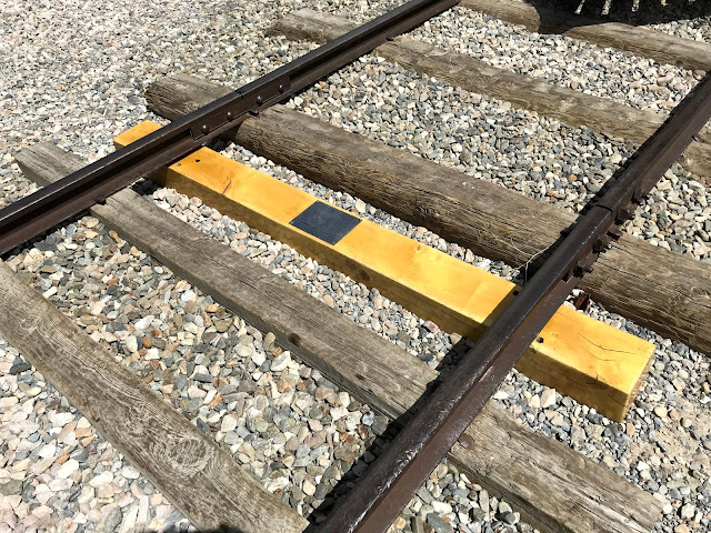
When Promontory was finally designated as the joining place, a crosstie made of polished California Laurel was laid with predrilled holes. Four precious metal spikes were symbolically driven, a gold spike from California, a silver spike from Nevada, Arizona's gold and silver spike, and a second gold spike commissioned by the San Francisco News Letter newspaper. A special gold plated spike hammer was used and the tie was made by Strahle and Hughes, a billiard table manufacturer.

Immediately after the ceremony, the spikes and the ties were replaced by a conventional tie and three iron spikes were driven into place. A fourth iron spike was wired to the telegraph and a regular iron spike hammer so that when the last spike was struck, the Nation could "hear" the blows. Leland Stanford from California took a mighty swing at the spike and missed, hitting the tie instead. Then Thomas Durant from the Union Pacific took a feeble swing and did not even hit the tie! A regular rail worker drove home the last spike and the telegrapher sent the message "D-O-N-E" at 12:47 pm, Monday, May 10, 1869.

California's golden spike and Nevada's silver spike reside today in the museum at Stanford University in Palo Alto, California. Arizona's disappeared for a bit, then showed up in the Museum of the City of New York. The whereabouts of the second golden spike is unknown, but was probably returned to the newspaper that commissioned it and was most likely destroyed in the Great Earthquake of 1906 in San Francisco, along with the Laurel tie that up till then was on display in the offices of the Southern Pacific Railway, the successor to the Central Pacific.

A portion of the gold used in the making of the Golden Spike was used to make four rings: one was given to Leland Stanford, one to Oakes Ames, the president of the Union Pacific, one to President U.S. Grant, and the last to Secretary of State William H. Seward.

Today the site is a commemoration of the immense effort needed to tie the country together, both figuratively and literally. Former Civil War enemies worked side by side, with immigrants and former slaves as well. 


Reproductions of Jupiter and 119 make ceremonial short trips for the crowd, belching black coal smoke and white steam! Jupiter, originally a wood burning locomotive since wood was plentiful in the west, and 119 from the east, a coal burner, were the centerpieces of the Golden Spike ceremony.


One of the engineers had to adjust the tone of the steam whistle.


Number 119, from east, was of a similar style, but with minor cosmetic differences.


A few more photos of the locomotives:


The Golden Spike and special commemorative tie are marked.


119 made it's approach to the Visitors Center with bell ringing and steam whistle blowing!

An American Flag with 20 stars flies over 119.


Ties used by the Union Pacific were hewn from any available timber found in the plains. They weren't nice and straight like the ones the Central Pacific cut from Sierra Nevada Douglas Fir trees.


It was beginning to get cold on this partly cloudy day, so we headed indoors!


I had to steal this photo of 119!


An auto tour loop on the east side of the National Monument provided a spectacular view of the Great Salt Lake Basin.

Dubbed "The Last Cut", this was the last obstacle faced by the Union Pacific, just miles from the Golden Spike location. All of the excess material was moved by hand, stacked neatly on the side with the heaver and larger stones on the bottom to stabilize the pile, and then tracks were laid in the cut. All of the iron rails were removed during World War II to be used in the war effort. The ties were removed and recycled into flooring, cabinetry, and artwork. This entire area was abandoned when a railroad was constructed across the Great Salt Lake, eliminating some 36 hours of train time from the northerly route that skirted the lake.


Thunder clouds were beginning to gather as we left the site. Beautiful!


Northrup Grumman has a huge testing facility in the hills east of the Golden Spike site. We checked out the tour schedule, but the program is currently closed.


A good day and a relief from rv travel!


Saturday, May 1, 2021

Winnemucca to Wells to Brigham City

 Leaving Winnemucca, Nevada, at about 10 in the morning, we wandered 186 miles east on I 80. Eventually we found the town of Wells, Nevada, and Mountain Shadows RV Park. We stayed here years ago and chose it this time for purely nostalgia reasons. Near as we can figure, our last visit was 30 years ago and....the park has changed some...

Seems as though it's a little smaller now....


But the pay phone is still there, and in operation from the look of it!


And the view of the neighboring mountains is still spectacular.


Today, Saturday the 1st of May, we left Wells and headed northeast, eventually ending up in the town of Brigham City, Utah. This is a very comfortable town, clean and quiet from what we could tell. There are many, many residences dating from the turn of the century to today. It's apparently becoming a bedroom community for Ogden and SLC.

Brigham City is also know for it's peach orchards. This is the wrong time of year for peaches, but we saw signs all over for peach pie, peach preserves, and peach ice cream! It's also home to the Worlds Greatest Wild Bird Refuge.


The Refuge is west of town several miles and is adjacent to the Great Salt Lake. We hope to visit tomorrow as we'll be here two nights. We arrived in Brigham City via a scenic route that curved north of the Great Salt Lake. Nevada 233 bails off of I 80 at the (town of) Oasis intersection, and heads north through high desert to Montello, Rosette, and Park Valley. The two lane road turns into Utah 30 and meets I 84 near Snowville.

Nevada 233 at about mile marker 75:


After 208 miles, we arrived in Brigham City and settled into the Golden Spike RV Park, and site 6. It's not a bad park, certainly well maintained, but narrow and hard to maneuver around in. It's located in an area of apartments along a main highway, so we expect it to be gobbled up in the near future.


This is Utah, so the LDS Temple dominates the skyline.


One other thing dominates the town, but I was unable to get a photo. Every couple of blocks through town we found a drive-in fast food place. No big deal, except every parking place of every joint was full! Must be that everyone goes out for a burger on Saturday night! There must have been a dozen places with a couple of dozen patrons at each one!

We're catching up on laundry and rest today and tomorrow, with a short day trip planned tomorrow. 

We'll be back!


Thursday, April 29, 2021

Day One. 336 Miles

We left home in NorCal about 9 am this morning and headed west toward Winnemucca, NV. What? Winnemucca is east of us! Well, the GPS kept telling us to drive directly north toward Interstate 80, then east. Having lived here for 40+ years, we knew that the indicated road was narrow, twisty, and steep. Fun to drive a car on, but not anywhere near fun in a motorhome. Our alternative was to head west toward the Bay Area and catch Business 80, which led us to I 80. Whew! Only added 50+ miles, but worth every second.

The Interstate is in good condition, considering that it's a major artery from the east into the San Francisco Bay area. After crossing the CA/NV state line, the road condition improved even more, which speaks to the way CA maintains their infrastructure. Getting through Reno was no big deal, and after 6 1/2 hours of Nevada desert, we pulled into New Frontier RV Park in Winnemucca. This park is only about 5 years old, so the trees are still small and shade is precious. The upside is that all sites are paved and the utility connections are very convenient. And the price ain't bad either.

We're in site 24 with a mix of rv's around us. Some nice and some nicer.....


The temp is 83 F, quite a change from the 60's and low 70's we've become familiar with, but welcome nonetheless. We understand that a cold front is moving in so we'll be cold again, I'm sure.

So, Day One is in the books. Just under 2% of the trip. We're on our way!


Wednesday, April 28, 2021

Time To Get Going

 Our extended but short trip to Redding a few months ago was so exciting that we needed to stay home and recuperate. We enjoyed Christmas as much as possible with family and friends and probably ate too much, but what'r ya gonna do these days?

At the end of January we hooked up with some friends and took the motorhome and Buddy to Arizona. What's/Who's Buddy?

Meet Buddy: 


And this is his happy owner:


The first photo was taken alongside the Colorado River near Parker, AZ. The second was taken near Ridgecrest, CA, at an OHV area called Charlies Place. In the background are the Trona Pinnacles, a natural and phenomenal series of formations left behind by ancient lake sediment.

We started our offroad adventures at Quartzsite, where we camped in the desert for 14 days. There are hundreds of miles of trails and thousands of things to be seen. This petroglyph appeared seemingly out of nowhere near an almost hidden "dripping spring".


Abandoned and operating mines dot the landscape. This was one of the first we happened on, and it seems to be still functional.


The desert is known for spectacular sunsets. We checked them our whenever we could:


We found an American Flag set in the middle of nowhere. It was set on the favorite place of a longtime desert rat, in his honor.


Apparently some others had the same idea! Lunch in Brenda, AZ.


We stopped along some semi-unnamed trail for a quick break.


OK, back to the sunsets.


Notice anything missing on Buddy? He's the one on the left.


There's supposed to be a spare tire mounted on the rack above the rear window like the SnS buggy on the right! Somewhere along the way the straps loosened up and the tire took flight. Once we realized that we had lost a part, we backtracked and found the entire assembly along side the trail! I'm sure that other riders had passed it, but not a soul took it. Thank you!

We took a ride one day to the town of Bouse, AZ. Now it's a wide spot on the road with a small park commemorating the town as the site of General George S. Patton's desert tank training facility. On the way, we wandered through an amazing area of red rocks.

And, yes. Thats a hundred dollar bill being used as a flag.....One of several, I might add.


Trona Pinnacles is an awesome sight. Accessed from Charlies Place, it's a nice desert trail ride to get there. Scattered over a wide area, the formations boggle the mind.


A visit to Charlies Place would not be complete without a photo of the buggy on Picture Rock.


Or any available rock...


A last photo of the friends we traveled with for more than a month, and who guided us through the growing pains of newbie utv owners.


Near sunset one night, we caught a glimpse of a hawk preparing for his evening meal.


Ok with the sunset again.


Home again at the end of February, we jumped into some "honey do's" and started prepping for the manufactured home that our daughter has kindly allowed us to place on her property. 

Here's son Jeff taking care of some concrete work for a remote electrical panel.


I guess some things never change. Here's a shot of a California driver who decided that he needed to turn left. Apparently the fact that there was limited space between other vehicles didn't bother him!


Another significant event that we've enjoyed in April was the 101st birthday of my Mother! Happy Birthday again, Mom!


Mom spends a bit more time in her recliner these days, but she is as sharp as the proverbial tack. Good on ya, Mom! Keep that sense of humor!

So here we are. Tomorrow we'll see if the motorhome will start, and if so, we'll be in Nevada tomorrow night. this trip is shaping up to be somewhat of an endurance contest, but we'll have a go and see where the wind blows us.

Stay tuned!