Our third day in the Teton area was spent going to Idaho Falls, some 65 miles to the west. It's a pleasant town and we did a few errands, some shopping, got lunch at Freddy's and a cup of coffee for the ride home! Short, but productive day.
Yesterday, Thursday the 16th, we took another trip into GTNP, since our time here is getting short. We entered the park at Moran, and immediately headed north along the east side of Jackson Lake, which we saw on Tuesday.
Driving through dense forest was very pleasant. We stopped occasionally to smell the pine trees and take a short hike. Before long we found ourselves at the South Entrance to Yellowstone National Park.
This particular sign came complete with Yogi Bear....Oh, Wait....No.....
Ok, it's decision time. Do we return the same way, or go look at some of Yellowstone? No brainer. So off we went toward West Thumb, an arm of Yellowstone Lake.
Just a short distance north we crossed over the western Continental Divide.
/and dropped down into the ancient volcano caldera to Yellowstone Lake. We ate lunch at Pumice Point and marveled at the size of this lake.
Now we're 22 miles into Yellowstone and need to make another decision. Return on the same road? No way. Short way past Old Faithful? Too many people, of course. Long way to Fishing Bridge, Canyon Village, Norris and Madison? Again....no contest. Off we go. Fishing Bridge is one of the iconic places in Yellowstone. It's centrally located, and up to recently, had a nice rv park. The rv park is closed this year, but the bridge and tourist stops are open.
Oddly, no fishing is allowed from Fishing Bridge! But the Yellowstone River is magnificent.
The road from Canyon Village to Tower-Roosevelt is closed for the summer, which was disappointing since it meanders through Dunraven Pass and past Mount Washburn, and is a lovely and breathtaking ride. So we turned west to Norris. We are truly committed to a long drive.
Somewhere near Norris we stopped at Mud Volcano to stretch our legs. Again we've got the people.
So, once again, our plan to see some mud pots up close was foiled by hundred of unmasked tourists. We did however, catch a glimpse of a male Bison munching green, tender grass. Shortly after this photo was taken, he showed his disdain for the crowds in a most unsavory, smelly, and noisy fashion, adding to the nitrogen content of the soil.
At this point, we had no choice but to continue on to West Yellowstone and work our way home. We had been on this road last week, but the choices are limited, so off we went. Donna took over driving and Sasha and I caught a couple of ZZZ's.
The ride home was uneventful and we arrived back in Victor at about 7 pm. Three hundred sixteen miles and eight hours later. My goodness, I certainly slept well last night! We'll be leaving here soon and heading south to Utah and Colorado. Stay tuned, 'cause the scenery will change!
BTW: at 2:30 pm on Friday afternoon, it's 84 degrees and raining.......
Friday, July 17, 2020
Tuesday, July 14, 2020
Grand Teton National Park. Day Two.
There are any number of driving and bicycling loops in Grand Teton National Park, as well as hundreds of miles of trails. Yesterday we drove from Jackson to Moose and then back along the foot of the Teton Range to Wilson before heading back over Teton Pass to Victor.
Today we explored a driving loop just a bit north. After we got to Jackson, we again climbed aboard US 191, the John D. Rockefeller Memorial Highway, and charged north to Moran Junction and the Moran entrance to GTNP.
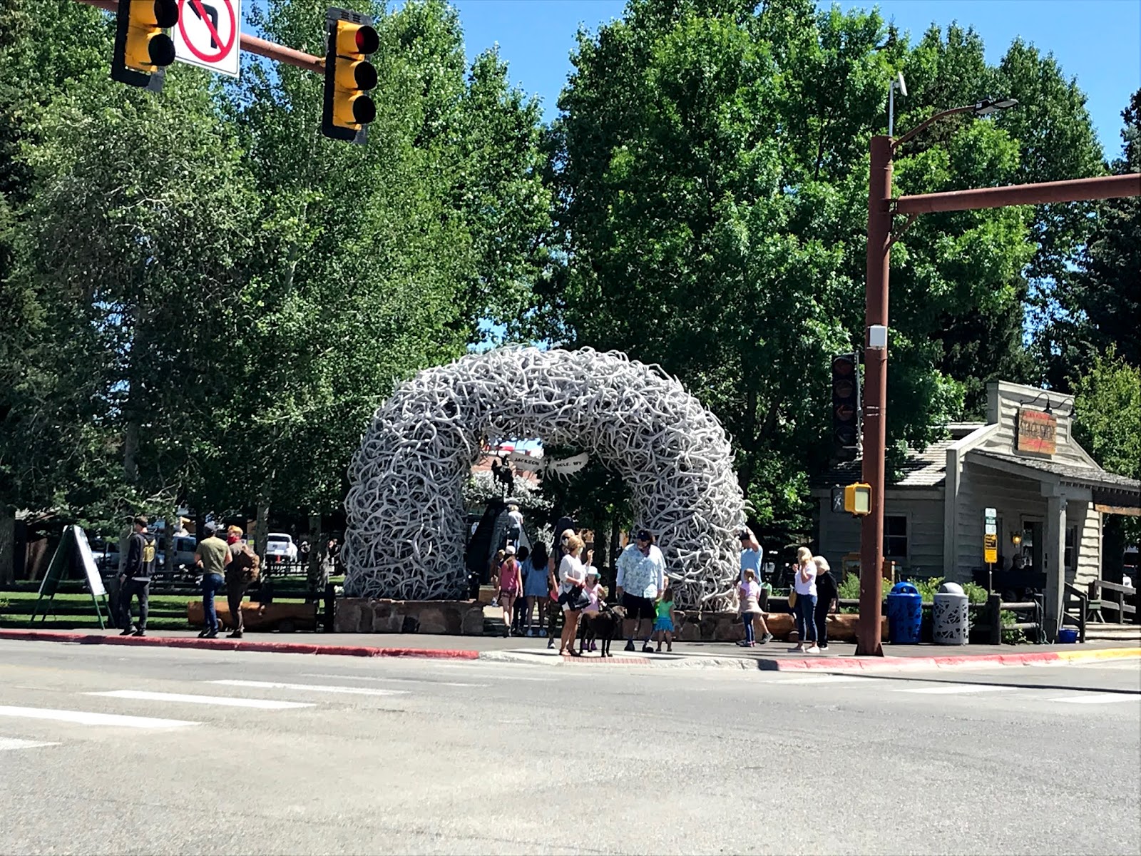
In Jackson, we glimpsed one of the famous Antler Arches, made from the annually discarded antlers of male elk. There is an arch at each corner of this city park, but there were way too many people and way too little parking for us to stop.
At our next stop we watched a rock climber scale a shear cliff face. Go for it!
North of Moose we began to get closer to the Tetons. It's almost a religious experience to contemplate such grandeur.
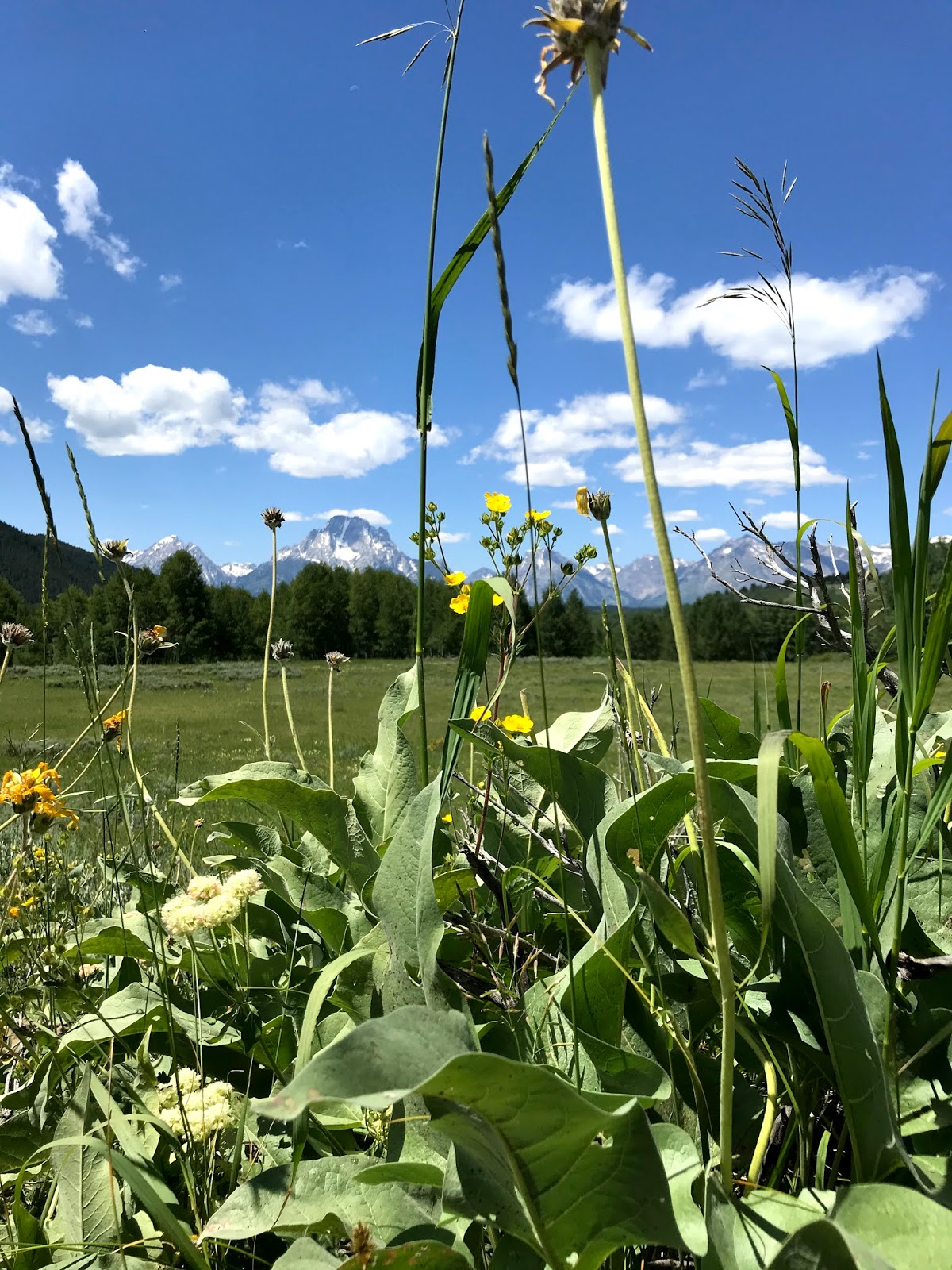
Spring comes late to this high elevation, and these wildflowers were competing with the peaks for attention.
Stopping along the southeastern edge of Jackson Lake gave us a whole new perspective on these famous peaks.
Across the lake:
And north toward Coulter Bay:
At 6,772 feet elevation, Jackson Lake freezes in the winter, but is spectacular in the summer.
Just south, Jenny Lake is almost hidden, like a blue gem tucked into a glacial fold.
The glaciers on Mt Moran are receding due to a warming climate. They have lost a significant amount of mass in the last fifty years, but are still a magnificent sight, if even from a distance.
The water in Jenny Lake is just about as clear and cold as you could find anywhere!
It was getting on toward time to eat lunch, so we bailed off the highway onto a gravel road that led to Lupine Meadow, looking for a nice picnic spot. Unfortunately, this is what we found at the end of a two mile road:
So we backtracked onto the highway and went a little bit south to Teton Glacier turnout, where we slurped smoked clams, lightly salted parmesan crackers, nuts and fresh cherries while looking out the windshield at this:
I tell you what....this has got to be one of our favorite places. Each and every state in the Union has its appeal and its attractions, and they are all memorable. But this is somehow special.
Today we explored a driving loop just a bit north. After we got to Jackson, we again climbed aboard US 191, the John D. Rockefeller Memorial Highway, and charged north to Moran Junction and the Moran entrance to GTNP.
In Jackson, we glimpsed one of the famous Antler Arches, made from the annually discarded antlers of male elk. There is an arch at each corner of this city park, but there were way too many people and way too little parking for us to stop.
At our next stop we watched a rock climber scale a shear cliff face. Go for it!
North of Moose we began to get closer to the Tetons. It's almost a religious experience to contemplate such grandeur.
Spring comes late to this high elevation, and these wildflowers were competing with the peaks for attention.
Stopping along the southeastern edge of Jackson Lake gave us a whole new perspective on these famous peaks.
Across the lake:
And north toward Coulter Bay:
At 6,772 feet elevation, Jackson Lake freezes in the winter, but is spectacular in the summer.
Just south, Jenny Lake is almost hidden, like a blue gem tucked into a glacial fold.
The glaciers on Mt Moran are receding due to a warming climate. They have lost a significant amount of mass in the last fifty years, but are still a magnificent sight, if even from a distance.
The water in Jenny Lake is just about as clear and cold as you could find anywhere!
It was getting on toward time to eat lunch, so we bailed off the highway onto a gravel road that led to Lupine Meadow, looking for a nice picnic spot. Unfortunately, this is what we found at the end of a two mile road:
So we backtracked onto the highway and went a little bit south to Teton Glacier turnout, where we slurped smoked clams, lightly salted parmesan crackers, nuts and fresh cherries while looking out the windshield at this:
I tell you what....this has got to be one of our favorite places. Each and every state in the Union has its appeal and its attractions, and they are all memorable. But this is somehow special.
Monday, July 13, 2020
Ashton. ID to Victor, ID 78 miles (and we took the long way)
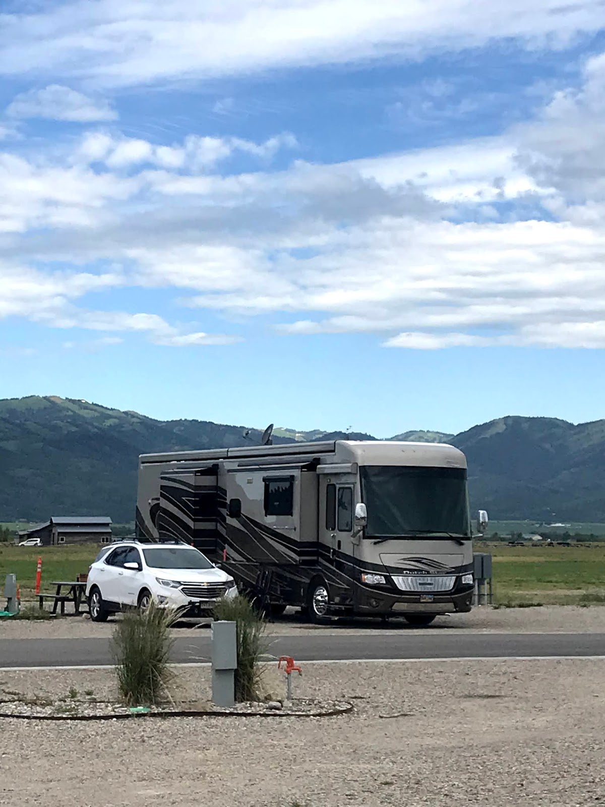
We spent a nice week with Roger and Mary in Aspen Acres RV Park just outside of Ashton, Idaho, but on Sunday it was time to venture out again. Check out time was at noon, and check in at our next destination was at one, so we took the long way around the barn to get to Victor, Idaho. Victor is home to the Teton Valley Resort. This "resort" isn't....but it's certainly nice enough. It's a work in progress, with out site 14 being in the newest expansion, and therefor not much more than a paved street and a lot of gravel.
We are, unfortunately, on the west side of the park, with nothing to block the howling wind from taking us away! It appears that concrete pads and windbreaks will eventually be added, but for now, the $65 nightly rate is about a third high. But it's all about location. We didn't want to stay in the tourist areas of nearby Grand Teton National Park, so this rv park fits the bill.
Monday morning we decided that a day trip into GTNP was in order, so we started east on ID 22 over Teton Pass into Jackson. Along the way we crossed into Wyoming.
And, indeed, the yellow sign turned out to be more than accurate! This route is the preferred escape route for us as we're going south toward Colorado, but after driving it in the car, we decided to find an alternate route!
Our first glimpse of Jackson Hole (the name of the valley that that town of Jackson is in) came as we were about half way down the east side of the mountain range.
We passed through the hamlet of Wilson and on into Jackson. I didn't take a photo of anything in Jackson because the traffic was very heavy and the sidewalks were shoulder to shoulder with unmasked tourists. Not willing to risk our health, we continued on to US Highways 189/191/26/89 north where we stopped at the National Elk Refuge turnout. It's easy to see why the animals love this place! Miles of meadow and abundant water must be Elk Heaven!
We scanned the area with binoculars, but didn't see any critters, so on we went north to the entrance to Grand Teton National Park. The three major peaks are over Donna's right shoulder. Mount Moran, Grand Teton, and Mount Bannon.
The mountain range from the east side is spectacular, and we snapped photos wherever we could.
We bailed off the highway at Moose (the town, not the critter), and began a southward loop on the Moose Wilson Road. Just as we turned, we noticed that a weather front was creeping over the valley.
A bit farther along this one lane road, we came across a "Moose Meadow". Didn't see any Moose (Meese?), but it was a beautiful meadow.
A quick look at the summer slopes of Teton Village imagines what this area must be like in the middle of winter. The Village is mostly acres and acres of condos, restaurants, and parking lots, so no photos here...
The nearby airport is suitable for small jet aircraft, and there were a dozen or more parked there. We saw yet another one about to land. See that tiny silver spot in the center at the base of the mountain?
We pulled off the road for a light lunch in an area with thousands of wildflowers.
After a pleasant drive, we climbed back over Teton Pass, 10% grades on both sides, and cruised back into Victor with memories of awesome mountain peaks dancing in our heads.
We are, unfortunately, on the west side of the park, with nothing to block the howling wind from taking us away! It appears that concrete pads and windbreaks will eventually be added, but for now, the $65 nightly rate is about a third high. But it's all about location. We didn't want to stay in the tourist areas of nearby Grand Teton National Park, so this rv park fits the bill.
Monday morning we decided that a day trip into GTNP was in order, so we started east on ID 22 over Teton Pass into Jackson. Along the way we crossed into Wyoming.
And, indeed, the yellow sign turned out to be more than accurate! This route is the preferred escape route for us as we're going south toward Colorado, but after driving it in the car, we decided to find an alternate route!
Our first glimpse of Jackson Hole (the name of the valley that that town of Jackson is in) came as we were about half way down the east side of the mountain range.
We passed through the hamlet of Wilson and on into Jackson. I didn't take a photo of anything in Jackson because the traffic was very heavy and the sidewalks were shoulder to shoulder with unmasked tourists. Not willing to risk our health, we continued on to US Highways 189/191/26/89 north where we stopped at the National Elk Refuge turnout. It's easy to see why the animals love this place! Miles of meadow and abundant water must be Elk Heaven!
We scanned the area with binoculars, but didn't see any critters, so on we went north to the entrance to Grand Teton National Park. The three major peaks are over Donna's right shoulder. Mount Moran, Grand Teton, and Mount Bannon.
The mountain range from the east side is spectacular, and we snapped photos wherever we could.
We bailed off the highway at Moose (the town, not the critter), and began a southward loop on the Moose Wilson Road. Just as we turned, we noticed that a weather front was creeping over the valley.
A bit farther along this one lane road, we came across a "Moose Meadow". Didn't see any Moose (Meese?), but it was a beautiful meadow.
A quick look at the summer slopes of Teton Village imagines what this area must be like in the middle of winter. The Village is mostly acres and acres of condos, restaurants, and parking lots, so no photos here...
The nearby airport is suitable for small jet aircraft, and there were a dozen or more parked there. We saw yet another one about to land. See that tiny silver spot in the center at the base of the mountain?
We pulled off the road for a light lunch in an area with thousands of wildflowers.
After a pleasant drive, we climbed back over Teton Pass, 10% grades on both sides, and cruised back into Victor with memories of awesome mountain peaks dancing in our heads.
Friday, July 10, 2020
Yellowstone National Park, West Entrance
Feeling a bit adventurous, and having a day to play with, we headed north on US 20 toward the West Entrance to Yellowstone National Park on Thursday, July 9th. It's a little under a hundred miles to the West Entrance, but the terrain gradually changes from rolling farmland to Lodgepole Pine covered mountains. It's a nice leisurely drive and the traffic wasn't too bad. but it's not the weekend.
We had planned to cruise around the small town of West Yellowstone, and perhaps take a walk on the main street, but after seeing yet another hundred or so T-Shirt shops, restaurants that didn't seem to be able to manage social distancing, and a thousand or so tourists crowding the sidewalk, we decided against it and drove on east into the park.
In Yellowstone's heart beats a supervolcano that last erupted 631,000 years ago. When the excitement subsided, the collapsed caldera measured 30 by 45 miles. That is roughly the area of Yellowstone Park today. The heat that powered that ancient eruption still fuels the parks geysers, fumaroles, hot springs and mud pots. At the West Entrance, we immediately left Idaho and crossed into Montana where we stopped along the Madison River to admire the view (and try to find some bears).
After a picnic lunch and a stroll with the dogs, we continued east. We soon found ourselves following the Gibbon River (don't know what happened to the Madison!), and pulled into the parking lot near the Artists Paintpots. Unfortunately, large crowds, minimal parking, and a hot day prevented us from taking the trail to the mud pots. There was absolutely no way to social distance, and face masks wee few and far between. Our mistake to think that the crowds would be smaller this year.
Realizing that dinner was in the crock pot and the shadows were getting a bit long, we u-turned and headed toward home. On the way, we stopped at Beryl Spring because there was no one there. Of course, as soon as we stopped, eight more carloads of people stopped! Nonetheless, the spring was impressive, and gave us a sense of the fire that is chuckling to itself under our feet.
Beryl Springs is so named because in the right light the 190 degree water resembles the blue-green gemstone. It is one of the hottest springs in Yellowstone.
Somewhere in here we had gone into Wyoming, so it became a three-state day! Another nice, relaxing day that ended with Mississippi Pot Roast, mashed potatoes, and salad!
We had planned to cruise around the small town of West Yellowstone, and perhaps take a walk on the main street, but after seeing yet another hundred or so T-Shirt shops, restaurants that didn't seem to be able to manage social distancing, and a thousand or so tourists crowding the sidewalk, we decided against it and drove on east into the park.
In Yellowstone's heart beats a supervolcano that last erupted 631,000 years ago. When the excitement subsided, the collapsed caldera measured 30 by 45 miles. That is roughly the area of Yellowstone Park today. The heat that powered that ancient eruption still fuels the parks geysers, fumaroles, hot springs and mud pots. At the West Entrance, we immediately left Idaho and crossed into Montana where we stopped along the Madison River to admire the view (and try to find some bears).
After a picnic lunch and a stroll with the dogs, we continued east. We soon found ourselves following the Gibbon River (don't know what happened to the Madison!), and pulled into the parking lot near the Artists Paintpots. Unfortunately, large crowds, minimal parking, and a hot day prevented us from taking the trail to the mud pots. There was absolutely no way to social distance, and face masks wee few and far between. Our mistake to think that the crowds would be smaller this year.
Realizing that dinner was in the crock pot and the shadows were getting a bit long, we u-turned and headed toward home. On the way, we stopped at Beryl Spring because there was no one there. Of course, as soon as we stopped, eight more carloads of people stopped! Nonetheless, the spring was impressive, and gave us a sense of the fire that is chuckling to itself under our feet.
Beryl Springs is so named because in the right light the 190 degree water resembles the blue-green gemstone. It is one of the hottest springs in Yellowstone.
Somewhere in here we had gone into Wyoming, so it became a three-state day! Another nice, relaxing day that ended with Mississippi Pot Roast, mashed potatoes, and salad!
Wednesday, July 8, 2020
Upper and Lower Mesa Falls
Took another short drive today. Just about 15 miles from our rv park, Henry's Fork river spills over two magnificent sets of waterfalls. Henry's Fork originates in Island Park Reservoir at the northern edge of the Caribou-Targhee National Forest and joins the Snake River near Interstate 15 north of Idaho Falls. Using our handy dandy guide to scenic day trips book, we stumbled upon the drive to the falls and decided to check it out.
Highway 47, the Mesa Falls Scenic Byway, leaves Ashton toward the east through miles and miles of rolling farmland. eventually it rises into the National Forest near Warm River.
This community dates back to 1896 when settlers arrived from Europe establishing farms and ranches. Years later, Warm River was the stopping point for travelers on a slow journey on a narrow muddy road to West Yellowstone, Montana. The road was eventually improved and became a major thoroughfare to Yellowstone Park. In 1947, Fred Lewis and his wife Bertha incorporated the Town of Warm River and Bertha became it's first mayor. The Rendezvous Dance Hall provided hamburgers, laughter, music, and fun on a Saturday night. When US 20 bypassed Warm River, the town faded into the shadows. The Rendezvous is gone, but they say that on a quiet evening, you may hear faint sounds of music.
Just a few miles further east is the first of our objectives. Falling 65 feet, Lower Mesa Falls can be viewed from an observation platform built by the Civilian Conservation Corps in the '30's.
Over a million years ago, a super-eruption of a volcano obliterated life in this part of Idaho and spread ash over much of the current US. In this area, the ash solidified into "Tuff", and the river has been patiently carving through it since.
Just a mile east, Upper Mesa Falls is a bit more spectacular!
Upper Mesa Falls cascades 114 feet over tuff that has been dated to 1.3 million years old. The river continues to slowly carve its way through the rock.
We don't usually go in for selfies, but this was such a nice day, and the river was gorgeous! And as long as one of us can go incognito.....
A nice drive on a beautiful day!
Highway 47, the Mesa Falls Scenic Byway, leaves Ashton toward the east through miles and miles of rolling farmland. eventually it rises into the National Forest near Warm River.
This community dates back to 1896 when settlers arrived from Europe establishing farms and ranches. Years later, Warm River was the stopping point for travelers on a slow journey on a narrow muddy road to West Yellowstone, Montana. The road was eventually improved and became a major thoroughfare to Yellowstone Park. In 1947, Fred Lewis and his wife Bertha incorporated the Town of Warm River and Bertha became it's first mayor. The Rendezvous Dance Hall provided hamburgers, laughter, music, and fun on a Saturday night. When US 20 bypassed Warm River, the town faded into the shadows. The Rendezvous is gone, but they say that on a quiet evening, you may hear faint sounds of music.
Just a few miles further east is the first of our objectives. Falling 65 feet, Lower Mesa Falls can be viewed from an observation platform built by the Civilian Conservation Corps in the '30's.
Over a million years ago, a super-eruption of a volcano obliterated life in this part of Idaho and spread ash over much of the current US. In this area, the ash solidified into "Tuff", and the river has been patiently carving through it since.
Just a mile east, Upper Mesa Falls is a bit more spectacular!
Upper Mesa Falls cascades 114 feet over tuff that has been dated to 1.3 million years old. The river continues to slowly carve its way through the rock.
We don't usually go in for selfies, but this was such a nice day, and the river was gorgeous! And as long as one of us can go incognito.....
A nice drive on a beautiful day!
Subscribe to:
Posts (Atom)