Wednesday, March 30, 2016

"Get Crackin!"

After a few days of overcast weather, last Monday was a great sunny and warm day. We spent most of the day walking on the beach and hanging close to home. Sasha needed to get some exercise, so across the street in front of the park we went, just a few hundred yards to the beach.

Even the DirectTV blimp was out for a leisurely drift across the sky!


The beach was almost deserted after the Spring Break and Easter weekend crowds had left, and the air temp was in the high 70's. Almost made us want to go swimming!


Houston is known for it's oil industry. From financial support, to equipment suppliers and refining complexes, the area is , forgive me, immersed in oil. Feeling the need to get into Houston, we headed north from Galveston on Tuesday on I 45. Just across West Bay, we dropped into Texas City, a busy deepwater port. Known for it's petroleum refining and petrochemical production, it is the third largest city in Galveston County. In 1947 an explosion destroyed the port and nearly destroyed the town, but today all remnants of that tragedy have been erased. We lost count of the number of oil refineries in the area, but there are "a lot". From one point we counted six separate facilities. Oil is brought into the port from the gulf by pipeline or ship and sent to huge tank farms. The fields of tanks looked like Iowa cornfields.


All the petroleum eventually finds its way to the refining facilities where it is broken into various grades of fuel and chemicals. This is known as "Cracking" the oil, since it uses heat to break (crack) the petroleum molecules, which are essentially distilled in large vertical stacks and the result drawn off and piped away.


Back on I 45 after a tour through TC, we headed north through League City, Webster, and Nassau Bay to the Space Center Houston. Once inside, our first mission was to take a shuttle tour around the facility.


The lines were a bit long for the tram, and it was beginning to rain, but we all hung in there for one of the most interesting tours we've seen.


Built on a thousand acres of land donated by Humble Oil Company through Rice University, the Lyndon B. Johnson Space Center continues to be a vital part of America's space program. We learned that missions prior to liftoff are controlled by the Launch Control Center (LCC) located at NASA's Kennedy Space Center in Florida, but as soon as the tower is cleared, control is handed off to the Mission Control Center in Houston (MCC-H).

Our first stop was the Christopher C. Kraft Mission Control Center, named for the Flight Controller whose voice became a symbol of the space program.


This facility housed the original MCC used during the Moon landings. The building continues to house MCC for the Space Station, along with Mission Control facilities for Russia and China. Under construction directly below the "first" MCC is the MCC for Orion missions to Mars. Awesome!

MCC-H was used from the early 60's with the Gemini program, then through the Apollo missions. Mercury missions were handled by facilities at Cape Canaveral, Florida.

Apollo MCC was decommissioned after the moon landing program was scrapped, and the room gutted in preparation for another purpose. Unfortunately, the powers that be forgot that the center had been designated a national historic landmark. Public outcry bought about a reversal of plans and a rebuilding of the control center. All of the original equipment was located, down to chairs, phones, and carpet, and re-installed as it had been.


The comfortable theater seating we used while we listened to a short presentation was original to the facility as well. Strange to imagine astronauts families, government and contractor personnel, all watching tensely as the rockets lifted off, sat in these very same seats!

Our last stop of the (very damp) tour was the Saturn V Building located at Rocket Park. We didn't spend much time outdoors looking at the rockets used for early manned and unmanned flights, but took a peek at the Redstone rocket uses in the Mercury missions. Compare the size of the people to the rocket!


And then try to comprehend the vast size of the Saturn V rocket used in the later missions!


The physical size of the rockets first stage hits you like a rock. It takes your breath away trying to imagine the thrust created by these engines. In 2 1/2 minutes, the booster pushed the rocket 41 miles into the sky and reached a speed of 6,000 mph!


The Saturn V operated from 1967 to 1973, lifting the 45 ton Apollo spacecraft into orbit around the Moon, In 1973, the rocket was used to lift the 120 tone SpaceLab into orbit around the Earth. The entire building is devoted to housing this historic rocket, and it took us so long to walk around it that we missed our tram ride back to the Visitor Center! This is truly a remarkable engineering feat.


And to think that the early Mercury and Apollo missions were performed without the use of a computer! You can bet that the slide rules were clicking at light speed! Later missions, of course, had the benefit of IBM 7094 computers whose mainframes required entire rooms, using exotic cooling fluids, and having the memory of about 1/4 of an iPod…..

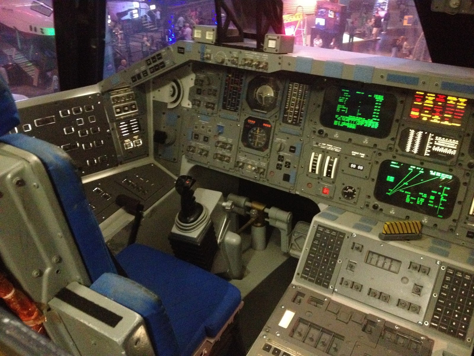
Back in the main facility, we toured a Space Shuttle cockpit,


Viewed a replica of Mans First Step on the Moon.


And marveled at the damage space debris can wreak on space craft.


After touring the full size orbiter used in the tv series Star Trek (which is either where this all started, or is where we're going),


we took a last loot at the Boeing Shuttle Transport Plane before heading back to Jamaica Beach.


Wednesday was our last full day in the Galveston area, so a little shopping and such was on the agenda. While in town, we stopped for lunch at the Cajun Greek (!).

Seafood Gumbo, Boudin Balls, and Shrimp Cocktail rounded out our meal, and a great one it was!


I sincerely hope my cardiac support team knows that this was a last-day splurge! Yes, I still feel fine!

Sunday, March 27, 2016

Happy Peep Day!


Easter Sunday dawned a bit overcast, but with temps in the high 60's. By mid-morning, the clouds/fog had disappeared, and the temperature was in the 70's and climbing. Welcome to the Gulf!

We thanked the good Lord for his sacrifices that prompt us to celebrate Easter, had a cup of coffee on the patio, and set about discovering what is what in Galveston. Turns out that Jamaica Beach, where we're staying, is in the West Beach section of Galveston Island, and the city proper is near East Beach. Go figure. Heading east on Seawall Blvd led us to the best beaches we've yet seen on this trip.


Several cruise lines use Galveston as a base for their Caribbean trips, and we saw a Norwegian Cruise Lines ship and a Carnival ship tied up.


This fuel barge was tied up next to the Carnival ship (see above), and then left, heading for the refinery down the bay.


At the port, among a number of out-of-service oil drilling platforms, is the Ocean Star Offshore Drilling Rig Museum.


Along the gangway to the museum, several pelicans relaxed in the warm sun.


The Ocean Star Museum shows the entire process used for extracting oil from the sea, and demonstrates with hands on exhibits just how sophisticated the process is. We learned how drilling platforms are fabricated for specific depths of water as well as for different types of geologic formations. After specialized ships create three dimensional graphs of the ocean floor, ofttimes tens of thousands of feet deep, the drilling platforms or ships are placed in position, and the work begins. This drill bit is one of several used for differing types of material.


From the pipe deck, the derrick is huge. Thirty foot lengths of pipe are screwed together to form ninety foot long pieces that are raised by cables and positioned for attachment to the pipe projecting from the drilling platform.


There are several different types of drilling platforms: ships that remain in position using computer operated thrusters to compensate for current and wind conditions; shallow water platforms use "legs" that are jacked into position on the ocean floor, stabilizing the platform, and floating platforms held in place with huge cables anchored to the ocean floor. If placed over the city of Houston, the chains would completely encompass the city and its suburbs! This link from one of those chains weighs 540 pounds and is about 3 feet in length.


The operation requires years of planning and millions of dollars of investment. Current daily rates are astounding.


A couple of Roughnecks gave us the boot off the drill rig!


As we left the port, heading east, we drove down The Strand, a collection of historic buildings in the old commercial district that have been repurposed into restaurants, bars, and T shirt shops.


The site of old Fort San Jacinto, at the extreme east end of Galveston Island, is a great place to check out the ships moving into the Intercoastal Waterway.


We stopped at the Island Fish Market for some fresh jumbo shrimp to have with our grilled steaks for dinner, and then looked at a new vacation home. It's built on pilings to avoid most of the storm surge that happens often in this area, and includes a balcony for watching the sunset over the Gulf of Mexico. Sadly, the realtor was not available this Sunday, so we had to take a pass on this one. Only 2 million (we'll keep looking).


Saturday, March 26, 2016

It's Jamaica Beach, Mon!

Jamaica Beach is a resort community one hundred eight eight miles from our last stop in Aransas Pass, and just a few minutes south of Galveston, Texas. It's located on Galveston Island, a continuation of the barrier island chain that we've been following since South Padre Island, and protection for Galveston Bay, which is the port for the city of Houston.

As we left the "Coast Bend" this morning, we found ourselves inland on Texas 35, a nice two-lane highway that travels through immense fields of newly planted corn. Yes, farmland! These fields were tremendous, and of course, we met several large farm vehicles on the road.


Cruising through Port Lavaca, Bay City, and Freeport got us to Jamaica Beach RV Resort. This is a small park, with narrow sites, but the sites have concrete pads to park on and good utilities. The water pressure is phenomenal, and the wifi is ok. We're in site 11, which is on the end of a row next to the path to the beach, so we're happy. On the other side, the motorhome seems to be unoccupied, so we're by ourselves!

This is the view from our windshield, with a nice beach house the only thing between us and the water.


The lower power line is just at about the line between the ocean and the sky.

We just had to walk over to the beach to watch the sailboats, and take a comfortable stroll. The wind, for a change, is not blowing a gale, and the temp was about 75 F. Nice!


Sasha had a ball on the beach! She had been cooped up all day, and needed to get out! Even though she was supposed to be on a leash, we found a deserted section of beach, and Sasha found a stick, so we were all happy!


I'm sure we'll spend some more time on the beach while we're here!

Friday, March 25, 2016

Two Museums

The windy, uncomfortable weather continued yesterday, so we decided to spend the day in Rockport, Texas. We had made arrangements to have lunch with our friends Dan and Ann there, so it was a good excuse to check out the town.

One of the first things you see as you come into town from the south is the Mathis House. Built in 1868 by John M. Mathis, who was the first mayor of Rockport. Lovingly restored and maintained, it is on the Texas Historical Landmark list.


Rockport is a wonderfully clean and bright little town, obviously upscale, and with a well designed waterfront.


Walking through an adjacent greenbelt, we saw a tribute to the Blue Crab that the area is famous for.


At 24 feet tall and 18 feet across, it would be dinner for a whole lotta people!

The Texas Maritime Museum occupies a prominent location near the waterfront.


One of the major exhibits in the museum tells of the 1684 expedition of the frenchman Robert LaSalle. There is a whole lot more to his name, but I've taken the liberty of shortening it…

The expedition's purpose was to establish a French colony at the mouth of the Mississippi, but when three of the four ships that left France sank or were captured, the mission failed. One ship was captured by Spanish privateers near Haiti, and two ships sank in Matagorda Bay, just north of Rockport. The flagship, the LaBelle, is represented by a large and impressive hand-made model.


Four main themes are exhibited at the Museum: Exploration and Settlement, Boatbuilding and Shipbuilding, Offshore Oil and Gas Exploration, and Commercial and Sportsfishing.  Each area contains a wealth of information. We learned about shipbuilding in Texas, The GIWW, or Gulf Intercoastal Waterway, which stretches from the southern tip of Texas all the way to Florida, and how the Texas Navy staved off a Mexican invasion during the Republic Period. A small section is devoted to the search for oil offshore, and describes how the various types of drilling platforms operate. Curiously, the platforms provide a haven for sea life when they are offshore, and after they reach the end of their useful life, are sunk to provide artificial reefs.

From the observation deck of the museum we spotted a "Shrimper" tied up next to Mom's Bait House.


The nets are a clever design that funnels shrimp into a narrow tube while allowing turtles and other fish to escape. I didn't know that the nets (one on each side of the boat, hanging from the outriggers when they are deployed) ride along the sandy bottom of the bay. Once considered to be only bait for larger fish, shrimp are now a staple in seafood restaurants.

Posted on the side of Mom's, above a rusted metal folding chair, are a number of "fish stories".


After a great lunch at Paradise Key Dockside Bar and Grill with Dan-n-Ann, we took the long way home via Goat Island State Park. By the way, Donna ordered and enjoyed Blue Crab, and I immersed myself in Crawfish Étouffée! No photos, the food disappeared too fast!

Goat Island provides a number of improved campsites right on the beach. Every one is booked for the season far in advance, but with electricity and water available, and a dump station nearby, it's no wonder.

Part of the Park is located some distance away from the beach. Named simply the Big Tree, this Coastal Oak is documented to be over 1,000 years old!


Today, we needed to return to downtown Corpus Christi to rescue my bicycle. As you remember, it took a bit of a fall a while ago, and needed some professional help. A new rim, tire, tube and such got it going again, so we dropped by The Pedal to pick it up. On the way back to Aransas Pass, we took a side trip to the Corpus Christi Museum of Science and History.

We got lost for awhile in the Geology and Natural History area, looking at everything from


to some of the most beautiful Geodes we've ever seen.


There's nothing common about this Common Sundial,


or this Golden Cowrie.


In a featured exhibit, guns and ammo were on display. From cannon to blunderbuss's, the history of guns was presented from the invention of gunpowder by the Chinese, to the heavy weaponry of pirates and privateers. Two examples caught my attention, an intricately decorated pistol:


And, an item that I would never have thought would have survived for almost 500 years!


The observation platform provides a view of the water feature in the center of the Bay Front park. It's a beautiful area that was constructed after a hurricane wiped out 85% of Corpus Christi in 1919.


Up to that time, the city wasn't protected by a seawall, but the event convinced even the most skeptical of the need for protection.

In the Columbus room of the History pavilion, we learned details of the Spanish conquest of Central America. This is an extremely sad era in the new world, because the Aztecs had developed a highly sophisticated society that was exterminated by the Conquistadores. Decimated by previously unknown diseases and fighting an enemy with superior weaponry, the native population had no chance. The lust for gold drove the invasion, and scores of ships returned to Spain with stolen treasures.

Several examples of jewelry are on display, most of them reproductions for obvious reasons, but this small piece seemed to exemplify the Aztec life.


A little known fact, at least to me, is the fact that horses originated in North America, but disappeared thousands of years ago, only to be reintroduced by Europeans.


The Museum is a great resource for history of the area, and provides kids with "hands on" science and natural history exhibits. It was well worth the $7 ticket.

The burger chain "Whataburger" was begun in 1950 in Corpus Christi, and is now a well known chain across 10 states with over 700 stores. A sponsor for local athletic stadiums and civic area, Whataburger's flagship store and largest (at 6,000) feet, is located on the Corpus Christi Bayfront, just a few blocks from the Science and History Museum. We had to try it!


With a couple of burgers under our belt, we headed back to Nessie to prep for the next part of our summer trip.

Stay tuned!